The Fanling Bypass is a massive, multi-billion-dollar bet on the future of Hong Kong’s Northern Metropolis. While the government presents the new Eastern Section as a simple fix for regional gridlock, the reality is far more complex. This bypass is the critical plumbing for a planned influx of nearly 200,000 residents into the Fanling North and Kwu Tung North New Development Areas. Without it, the existing infrastructure would buckle under the weight of a population surge that is already well underway.
To understand the stakes, one must look at the geography of the New Territories. For decades, the Fanling Highway has functioned as a single, overstressed artery. By diverting traffic from the town center and connecting the Sha Tau Kok Road directly to the Fanling Highway via a four-kilometer dual two-lane trunk road, the government hopes to shave minutes off commutes. But minutes are not the goal. Survival is.
The Infrastructure Lag
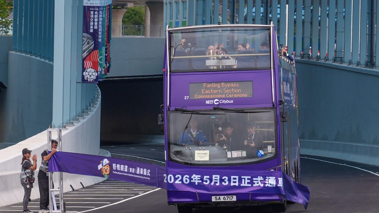
Hong Kong has a history of building "bridge to nowhere" projects that eventually find their purpose, but Fanling North represents the opposite problem. Here, the housing is arriving faster than the roads can carry the people. The Eastern Section of the bypass, which recently saw significant construction milestones, is designed to intercept traffic from the eastern side of the district before it ever touches the congested heart of Fanling’s traditional residential blocks.
If you have ever tried to navigate the Jockey Club Road during peak hours, you know the frustration. It is a slow-motion car crash of urban planning. The bypass seeks to pull roughly 30 percent of that volume away from the surface streets. However, the efficacy of this diversion depends entirely on the completion of the Western Section, creating a period of transition where the "bypass" might actually just move the bottleneck a few kilometers down the road.
Civil engineering in this corridor is an exercise in extreme constraint. Engineers are threading a high-capacity highway between existing villages, ecological sensitive zones, and the Ng Tung River. This isn't just about pouring concrete; it is about managing a hydraulic flow of vehicles in a space that was never intended for this level of density.
The Cost of the Public Housing Push
The sheer scale of the Fanling North development is staggering. We are looking at a transformation of rural and brownfield land into a high-rise forest. The bypass is the only thing standing between this vision and total logistical paralysis.
Critics often argue that the government prioritizes "hardware" over "software." In this case, the hardware is non-negotiable. If the first wave of public housing residents moves in before the bypass is fully operational, the political fallout will be severe. We have seen this play out in Tuen Mun and Yuen Long, where residents spent years trapped in "commuter hell" because transport links lagged behind residential occupancy.
The budget for these works is often opaque, buried under the broader umbrella of the Civil Engineering and Development Department’s (CEDD) New Territories North projects. When you factor in the noise barriers, the complex interchanges, and the land resumption costs, the price per kilometer rivals some of the most expensive roadworks on the planet.
Breaking the Bottleneck Myth
There is a persistent belief in urban planning called induced demand. It suggests that building more roads simply invites more cars, eventually returning the system to its original state of congestion. The Fanling Bypass faces this exact risk. While it is marketed as a relief valve for local residents, it is also a magnet for cross-border logistics and private vehicle owners who previously avoided the area.
To mitigate this, the bypass must work in tandem with the proposed Northern Link rail project. A road-only solution in the 21st century is a failing strategy. The bypass provides the immediate relief needed for construction logistics and bus routes, but the long-term viability of the Fanling North project rests on whether the government can convince these new residents to leave their cars behind entirely.
Engineering Challenges in the Eastern Section
The Eastern Section is a masterclass in modern viaduct construction. Much of the route is elevated to minimize the footprint on the ground and to bypass existing obstacles like the Fanling Highway and the MTR East Rail Line. These aren't standard bridges. They are massive, pre-cast segments that must be launched with surgical precision over functioning transit lines.
One overlooked factor is the integration of "Active Transport" alongside the heavy steel and concrete. The project includes significant pedestrian and cycling links. While these are often dismissed as "lifestyle" add-ons, they are functional necessities in a district where the distance between the new high-rises and the old market centers is too far to walk comfortably but too short to justify a car trip.
Environmental and Social Friction
You cannot carve a highway through the New Territories without hitting nerves. The bypass has required the relocation of long-standing communities and the clearing of agricultural plots. While the government points to the "greater good" of housing 180,000 people, the displacement of the "old" Fanling is a cultural cost that doesn't appear on the balance sheet.
Furthermore, the environmental mitigation measures—specifically the massive noise enclosures—have become a defining feature of the project. These structures are expensive and visually dominant, but without them, the planned housing units would be uninhabitable due to the decibel levels from the heavy goods vehicles streaming toward the Liantang/Heung Yuen Wai Boundary Control Point.
The Cross-Border Variable
The Fanling Bypass isn't just a local road; it is a vital cog in the Greater Bay Area integration machine. With the opening of new border crossings, the traffic profile of the New Territories has shifted from domestic commuting to international logistics. The bypass acts as a feeder for the Heung Yuen Wai Highway, which connects the border to the rest of Hong Kong.
This dual-purpose nature is the bypass's greatest strength and its potential Achilles' heel. If cross-border trade volumes exceed projections, the "relief" promised to local Fanling residents will vanish as the bypass becomes a parking lot for container trucks. The government is betting that by separating local through-traffic from border-bound freight, they can satisfy both the residents of the new public housing estates and the logistics industry.
Accountability and Timelines
The CEDD has been under immense pressure to deliver the bypass segments in sync with the "intake" of the public housing residents. Any delay in the roadwork manifests as a direct hit to the quality of life for thousands of families. The Eastern Section is currently the focus, but the real test remains the integration of the entire network.
We must scrutinize the "prevention of congestion" claim. True congestion prevention requires more than just a new bypass; it requires a radical rethink of how the New Territories North connects to the urban core of Kowloon and Hong Kong Island. The bypass solves a local problem, but it doesn't solve the "Bottleneck at the Tunnel" problem that plagues every commuter heading south.
The Northern Metropolis is often described in glowing, futuristic terms, but its success or failure will be decided by the mundane reality of traffic flow. If the Fanling Bypass fails to divert the predicted volumes, the entire housing strategy for the region is at risk of stalling. This is not just a road project. It is a stress test for the government's ability to build a functioning city from the ground up in one of the most densely populated places on earth.
The reality of the Fanling Bypass is that it is a defensive measure. It is a frantic attempt to catch up with a decades-long housing shortage. The concrete is still drying, but the pressure on the infrastructure is already at its peak. The only way forward is to finish the work, monitor the flow, and hope the math behind the induced demand doesn't prove the planners wrong.
Every meter of this road represents a compromise between environmental preservation, social stability, and economic necessity. As the first vehicles begin to use the Eastern Section, the focus will shift from the engineering marvels of the viaducts to the simple, brutal metric of the morning commute. If the tailbacks remain, the bypass will be remembered as an expensive sticking plaster on a deep structural wound. If it works, it provides the template for the rest of the Northern Metropolis to follow.
Stop looking at the maps and start looking at the timelines. The housing is coming. The people are coming. The road must be ready, or the vision of a seamless Northern Metropolis will remain stuck in traffic.