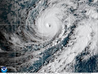
Residents across the Hawaiian archipelago are once again staring down the barrel of severe Pacific weather as Hurricane Lowell churns its way northward, tracking safely to the west of the island chain yet packing enough atmospheric punch to force emergency declarations and widespread tropical storm warnings.
At 120 mph, Lowell's core strength places it firmly as a major Category 3 system. While direct landfall is not currently projected, the geographic geometry of the storm means that Kauai and Niihau bear the brunt of the outer perimeter, where tropical storm warnings remain active. Emergency management officials have mobilized resources, urging local communities to secure properties, stock up on essential medical supplies, and prepare for extended utility disruptions.
The Mechanics of Displaced Impact
It is a common meteorological misconception that a storm must make direct landfall to wreak havoc. In the case of island geography, proximity often matters more than a direct hit. Lowell's vast wind field extends outward significantly, with tropical-storm-force winds reaching up to 175 miles from the center.
As the system passes to the west, it forces a radical shift in local wind patterns. Prevailing trade winds break down, replaced by a southerly flow that drags deep tropical moisture directly against the steep mountain ranges of the islands. Orographic lift takes over. Warm, moisture-laden air is forced upward rapidly, cooling and condensing into torrential downpours.
Forecasters anticipate rainfall totals reaching up to 14 inches in isolated higher elevations on Kauai, while the broader state faces a comprehensive flood watch. Water moves fast down basaltic slopes stripped of deep-rooting native vegetation in certain areas, turning dry gulches into raging torrents within minutes. Flash flooding remains the primary lethal threat of modern Pacific cyclones, outpacing even wind damage in historical casualty data.
Infrastructure Strain and Supply Vulnerability
Supermarket shelves in Lihue emptied within hours of the initial warnings. Bottled water, generator fuel, and non-perishable goods disappeared as residents braced for isolation. This routine scramble highlights a persistent vulnerability unique to isolated oceanic communities. Hawaii imports the vast majority of its food and energy supplies via maritime shipping lanes.
When a storm threatens, ports close, air traffic halts, and supply chains snap shut instantaneously. A single week of rough seas isolates communities far more effectively than any continental roadblock. Power grids, managed by local utilities, face constant stress from falling Albizia trees and heavy wind gusts hitting aging wooden infrastructure. While grid hardening efforts have accelerated over recent years, underground cabling remains sparse outside densely populated urban centers, leaving rural pockets exposed to days or weeks of darkness.
The Broader Oceanic Context
Lowell does not exist in a meteorological vacuum. This system is part of an active Central Pacific season that has kept emergency response networks on high alert. Simultaneous marine swells driven by distant systems create compounded coastal hazards, driving high surf up onto roadways and inundating normally dry beach parks.
Emergency response agencies now operate under a permanent state of heightened awareness, shifting from seasonal preparedness to year-round crisis management. Infrastructure investments must evolve beyond temporary sandbags and emergency shelters, confronting the structural reality of shifting weather baselines across the Pacific basin.
Residents on Kauai and surrounding islands are settling in for a tense cycle of weather shifts as the outer bands sweep ashore.
Hurricane Lowell Updates – Hawaiʻi Emergency Management Agency
This official portal from the Hawaiʻi Emergency Management Agency provides real-time warnings, evacuation routes, and county-specific instructions for residents tracking Hurricane Lowell's path.