The Western and Northern provinces of Rwanda are sliding down mountainsides. It is that simple, and it is that terrifying. If you look at the geographic data from recent years, especially the devastating events of May 2023, you see a country fighting a losing battle against its own topography. Heavy rains triggered floods and mudslides that claimed over 130 lives in a matter of hours. This is not just a seasonal inconvenience. It is an environmental crisis that threatens the very foundation of rural Rwandan life.
People often call Rwanda the land of a thousand hills. It is a beautiful phrase for tourism brochures, but a dangerous reality for agriculture and housing. When climate change accelerates rainfall patterns, those beautiful hills turn into vertical hazards. The water saturates the soil, gravity takes over, and entire villages lose everything they own. We need to stop viewing these events as unpredictable natural disasters and start treating them as a systemic challenge requiring immediate, aggressive intervention.
The Reality of Farming on the Edge of Disaster
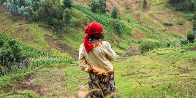
Agriculture drives Rwanda's rural economy. Over 60% of the population works in farming, often on slopes exceeding 25 degrees. When a landslide strikes, it does not just destroy a house. It strips away the topsoil. That topsoil takes centuries to form. For a smallholder farmer in districts like Gakenke, Karongi, or Rubavu, a single rainy afternoon can wipe out a generation of wealth.
They lose their crops, their terrace investments, and their future yields all at once.
The immediate response usually focuses on emergency food aid and temporary shelter. That is necessary, of course. But it misses the larger point. The real tragedy is the economic displacement that follows. Farmers return to unstable land because they have no choice. They clear the debris, plant beans or coffee again, and pray the next heavy rain waits a few years. It is a exhausting cycle of survival.
Where Current Mitigation Efforts Fall Short
The Rwandan government has not been idle. They have pushed for radical terracing, progressive terracing, and massive afforestation campaigns across vulnerable districts. You can see these terraces carved into the hillsides across the country. They are designed to slow down water runoff and retain soil.
Sometimes they work. Often, they fail.
The problem lies in implementation and maintenance. Deep-seated landslides, common in regions with weak geological formations like decomposed granite or schist, laugh at shallow terraces. If the terrace is not engineered with proper internal drainage, it actually holds water like a sponge. That added weight makes a landslide more likely, not less.
Agroforestry is another favorite solution among international donors. Planting trees stabilizes the upper layers of soil. But if you plant the wrong species, or if you don't allow the root systems time to mature before the next major storm cycle, the trees add canopy weight without providing structural support. When the slope gives way, those trees turn into battering rams, destroying homes downhill with even greater force.
The Human Cost of Relocation Policies
To save lives, Rwanda has relied on moving people. The government designates high-risk zones and relocates families to integrated model villages, known locally as Imidugudu. On paper, this is a win. Families get safer housing, access to electricity, clean water, and schools.
The social reality is much more complicated.
Land is deeply tied to identity and livelihood in Rwanda. When you move a farmer five kilometers away from their traditional plot to a centralized village, you create a logistical nightmare for them. They now have to walk hours uphill just to tend to their fields. Furthermore, the land they left behind often remains their only source of income, meaning they still spend their days in the exact hazard zones the government tried to pull them out of.
We also have to talk about density. Rwanda is one of the most densely populated nations in Africa. There simply is not enough flat, safe land to go around. Moving people means crowding them into specific zones, which puts immense pressure on local water resources and infrastructure.
Engineering a Way Forward Through Better Data
We cannot change the topography of Rwanda. We can change how we monitor it. Right now, the country relies heavily on reactive mapping. A landslide happens, teams go out, they map the damage.
We need to shift entirely to predictive modeling.
Organizations like the Rwanda Environment Management Authority (REMA) and the Rwanda Meteorology Agency need better funding for high-resolution LiDAR mapping and satellite interferometry. This technology tracks microscopic movements in hillsides long before they visibly crack. If a slope moves a few millimeters over a month, that is your warning sign. You evacuate before the rain starts, not after the mud hits the roof.
Investing in low-cost, community-led early warning systems is the most practical step forward. Simple rain gauges managed by local village leaders, combined with clear communication channels via mobile networks, save lives. If a village knows it has received 100 millimeters of rain in 24 hours, they don't wait for a government order to move to higher ground. They pack up and leave immediately.
Changing How We Build and Plant
Long-term survival on these hills requires changing our relationship with the soil. Standard crops like maize and beans have shallow root systems that offer zero structural support to a hillside. Rural communities must be incentivized to transition steep slopes to perennial crops with deep, binding root networks. Think bamboo along riverbeds and steep ravines, or specific varieties of coffee and tea that anchor the earth effectively.
Construction habits must change too. Cutting into the foot of a slope to create a flat pad for a house is a death sentence. It removes the natural support of the hill, making a landslide inevitable during the next downpour. Local building codes must strictly enforce slope stabilization techniques, like retaining walls made of gabions, for any structure built on an incline.
If you live in or work with communities in high-risk zones, your next step is straightforward. Audit your local terrain. Look for the early warning signs: tilted trees, new cracks in the ground, or doors that suddenly won't close because the house foundation has shifted. Do not wait for the next major storm season to plan an evacuation route. Work with your local cell leaders to identify safe zones now, protect your upslope drainage channels from clogging, and plant deep-rooting vegetation along your property boundaries. The earth will continue to shift, but foresight determines whether that movement results in a statistics report or a story of survival.


