The border is a line drawn in the sand that the rest of the world refuses to see.
When you cross from Ethiopia into Somaliland, the change isn't just atmospheric; it is bureaucratic, psychological, and deeply physical. You leave behind a recognized giant and enter a ghost. Or rather, a ghost that refuses to stop breathing. For thirty-three years, this self-declared republic on the Horn of Africa has printed its own money, elected its own presidents, and maintained a peace that its neighbor to the south—Som
The Map to Nowhere and the Ghost of a Nation
News, Travel
The ink is barely dry on the paper, but the border it defines has been bleeding for decades.
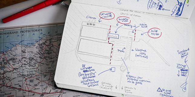
In the high, dust-choked offices of Hargeisa, the capital of a country that technically doesn't exist, a cartographer’s pen carries more weight than a diplomat’s handshake. For most of us, a map is a utility, a blue-dot guide to the nearest coffee shop or a way to navigate a highway. But for the people of Somaliland, a map is an act of defiance. It is a scream into the void of international indifference.
When a journalist from Le Monde arrives here, she isn't just reporting on a geopolitical quirk. She is documenting a ghost that refuses to stop haunting the Horn of Africa.
Somaliland sits on the Gulf of Aden, a jagged piece of land that looks exactly like a country. It has a president. It has a flag. It has a currency—the Somaliland shilling—that you can trade for stacks of bills in open-air markets. It has an army that guards its borders and a police force that keeps its streets safer than many recognized capitals. Yet, if you look at a standard United Nations map, this entire territory is swallowed by the chaotic, sprawling borders of Somalia.
To the world, Somaliland is a phantom limb. To the four million people living there, it is the only home they have ever known.
The Weight of a Line
Imagine standing at a border crossing where the guards wear crisp uniforms, stamp your passport with an official seal, and welcome you with a smile. You walk fifty feet, and suddenly, those stamps are worth nothing. They are legally invisible. This is the daily reality of the "State that isn't."
The cartography of this region is a mess of colonial scars and broken promises. In 1960, British Somaliland gained independence, enjoyed five days of sovereign bliss, and then rushed into a union with Italian Somalia to the south. It was a romantic dream of "Greater Somalia" that quickly curdled into a nightmare. By the 1980s, the regime in Mogadishu was carpet-bombing Hargeisa.
When the journalist sits down to draw this place, she isn't just tracing coastlines. She is tracing the memory of the 1991 declaration of independence, a moment when the north decided it would rather be a functional ghost than a dying limb of a failed state.
But drawing a map of a non-existent country is a political minefield. Where do you put the line? If you draw it according to the 1960 colonial borders, you anger the federal government in Mogadishu, which sees the territory as a rebellious province. If you don't draw it, you erase the lived reality of millions of people who haven't seen a Mogadishu official in thirty years.
The cartographer's dilemma is the world’s hypocrisy: we value the "territorial integrity" of a map over the actual peace and stability of the people living on the ground.
The Currency of Recognition
In Hargeisa, the streets are a symphony of survival. Money changers sit behind massive walls of cash, secured by nothing more than a bit of wire mesh. They don't need armored cars. The social contract here is stronger than the legal one.
Consider a shopkeeper named Ahmed. Hypothetically, he sells electronics in the heart of the city. Ahmed pays taxes to the Somaliland Revenue Authority. He follows laws passed by the Somaliland Parliament. When he has a dispute, he goes to a Somaliland court. But if Ahmed wants to export his goods or travel to Europe for business, he is a man without a country. His passport is a souvenir. His bank cannot easily access the international SWIFT system.
The human cost of this "non-existence" is a slow-motion economic strangulation.
Because the world refuses to recognize the line on the map, Somaliland cannot access World Bank loans or IMF credit. They are forced to build a nation on pocket change and grit. It is a DIY democracy. They have held multiple elections with biometric iris-scanning technology—something many "recognized" nations haven't even mastered—yet they remain the world's most successful secret.
The journalist’s task is to capture this friction. How do you draw the tension between a bustling, peaceful market and the fact that, on paper, this market is located in a war zone hundreds of miles to the south?
The Geography of Silence
Mapping isn't just about the physical world; it’s about what we choose to see.
When we look at a map of Africa, we see the legacy of the 1884 Berlin Conference, where European powers used rulers to divide a continent they didn't understand. Those lines have stayed mostly frozen, even as they sparked civil wars and ethnic cleansings. The international community clings to those old lines with a religious fervor, terrified that if they allow Somaliland to be "real," the entire map of Africa will start to unravel like a loose sweater.
But the silence is deafening.
Somaliland has stayed peaceful while its neighbors burned. It has fought Al-Shabaab and kept piracy at bay along its coast. It has hosted refugees. It has done everything a "good" state is supposed to do. And in return, the world gives it a pat on the head and a refusal to acknowledge its name.
The journalist-cartographer travels through the dry, rocky interior, where the heat shimmers off the red earth. She sees the nomadic herders whose lives are dictated by the search for water, not the politics of recognition. But even they feel it. When the rains fail and the livestock die, the aid that flows to recognized nations is often diverted or delayed because Somaliland doesn't have a seat at the table.
The Pencil as a Weapon
Every stroke of the journalist’s pen is a confrontation.
When she draws the border between Somaliland and the Puntland region, she is entering a "grey zone." These are areas where the map blurs, where local clans switch allegiances, and where the threat of conflict is never far away. To draw a solid line is to take a side. To draw a dotted line is to admit the fragility of the peace.
There is an inherent violence in cartography. It forces the messy, overlapping realities of human life into rigid categories. But in Somaliland, the map is also a tool of hope. If they can just get the world to look at the drawing—really look at it—maybe the ghost will finally take on flesh and bone.
The journalist records the stories of students at the University of Hargeisa. They are brilliant, ambitious, and frustrated. They study international law in a place that the law ignores. They are masters of a digital world that doesn't recognize their IP addresses as belonging to a sovereign state.
One student might tell her: "I am a citizen of a country that exists in my heart, in my wallet, and in my history. Why is that not enough for your maps?"
The standard article would tell you that Somaliland’s status is "unresolved." It would list the dates of various treaties and the names of regional blocks like the African Union. It would tell you that recognition is "unlikely in the near future."
But that misses the point entirely.
The point is that Somaliland exists regardless of whether we acknowledge it. The "State that doesn't exist" is currently building ports with DP World, signing deals with Ethiopia for sea access, and creating a reality that the maps will eventually have to catch up to.
Power doesn't always come from a UN vote. Sometimes, it comes from the quiet, stubborn refusal to disappear.
The journalist packs her notebooks and her sketches. She leaves the dust of Hargeisa behind and returns to a world of passports that work and borders that are taken for granted. But the map she carries is different now. It is no longer a dry document of coordinates and topography.
It is a portrait of a people who have built a house in a storm and are still waiting for the neighbors to acknowledge the address.
The real story isn't the "State that doesn't exist." It’s the world that pretends it can’t see what’s right in front of its eyes. We cling to our old maps because they make us feel safe, because they suggest the world is an ordered place where the lines we drew a hundred years ago still mean something.
But go to Somaliland. Walk the streets. Smell the frankincense and the diesel. Feel the heat of the sun on the red sand.
Then try to tell those people they aren't there.