Summer heatwaves usually bring complaints about melting asphalt, dried-up lawns, and uncomfortable nights. But for archaeologists in Wales, a scorching summer is the ultimate gift.
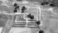
When topsoil bakes under relentless sun and rainfall vanishes for weeks, the Welsh countryside transforms into a massive photographic negative of its own history. Fields that look uniform from the ground suddenly display geometric rings, crisp straight lines, and complex enclosure grids when viewed from a light aircraft.
This isn't magic. It's soil chemistry and plant biology working together under severe drought stress.
The Science of Cropmarks and Parchmarks
How does a 2,000-year-old ditch reveal itself through a patch of barley or ordinary grass?
It comes down to differential moisture retention. Centuries ago, human hands dug ditches around Iron Age hillforts or laid stone foundations for Roman villas. Over time, those structures were abandoned, leveled, and plowed over.
When ancient ditches were backfilled, the soil filling them remained looser, deeper, and richer in organic matter than the surrounding undisturbed earth. In contrast, where stone walls or paved courtyards lie buried just beneath the surface, the topsoil layer is thin and rocky.
During normal rainy seasons, crops grow evenly across both types of ground. You'd drive right past a buried Roman fort without noticing a thing.
When a severe heatwave hits, everything changes:
- Green cropmarks: Crops growing over deeper, moisture-rich ditch fills draw water longer than neighboring plants. They stay vibrant green and grow taller, outlining ancient moats and boundary trenches.
- Parchmarks: Crops growing directly over shallow stone foundations exhaust their water supply fast. They wither, turn yellow, and die off prematurely, mapping out stone walls and road foundations in pale, parched lines.
Aerial archaeologists like Dr. Toby Driver from the Royal Commission on the Ancient and Historical Monuments of Wales (RCAHMW) rely on these subtle contrast shifts to spot lost monuments from low-flying aircraft.
Why the Frequency of These Discoveries Has Shifted
Historically, a "cropmark summer" was a rare event in the UK. Aerial survey teams used to wait five to seven years for a dry spell intense enough to scorch the landscape into revealing its secrets.
That schedule has fundamentally broken down. Extreme dry spells between spring and late summer now occur far more frequently.
While severe drought creates obvious challenges for agriculture and local ecosystems, it leaves aerial surveyors scrambling to document sites before rain returns and washes the evidence away. Once heavy rain hits, the crops recover or collapse, and the outlines vanish completely until the next prolonged dry spell.
It's a race against time every single time the sky clears.
Incredible Recent Discoveries Hidden Under Welsh Fields
Recent aerial mapping runs across mid, south, and north Wales have logged dozens of previously unknown or poorly understood sites:
- Neolithic Long Barrows: A 5,000-year-old burial mound near Welshpool produced its clearest cropmarks in three decades, allowing researchers to precisely map its boundary ditch.
- Vast Iron Age Cattle Corrals: A massive concentric enclosure measuring roughly 170 meters across emerged near Lampeter, giving specialists fresh evidence of prehistoric livestock management.
- Hidden Roman Structures: Scans over Caerhun (Canovium) in Conwy exposed clear outlines of buried Roman buildings within the fort walls.
- Unknown Settlements: Double-ditched farmsteads from the Iron Age or Romano-British eras have appeared in Ceredigion, filling in blind spots on local settlement density maps.
- Modern Military Relics: It isn't just ancient history. First World War practice trenches buried beneath modern golf courses at Deganwy stood out sharply against the dried turf.
Digital image processing now allows teams to enhance these aerial shots even further. By shifting color bands and rebalancing imagery captured from light planes and specialized drones, faint shadows turn into clear architectural blueprints.
What Happens After the Plane Lands
Taking photographs from 1,000 feet up is only step one. The real work happens during the wet winter months that follow.
Researchers manually map the high-resolution photographs, transforming distortion-corrected aerial imagery into precise CAD and GIS vector drawings. These blueprints get added directly to the National Monuments Record of Wales.
Local archaeological trusts and heritage bodies like Cadw use this data to update protection zones. Farmers learn where delicate buried archaeology lies so they can adjust deep-plowing schedules to avoid destroying fragile stone foundations.
If you want to track these discoveries yourself, don't grab a shovel. Ground digging without permission on protected sites is illegal and destroys context. Instead, explore the public Coflein database online, where the RCAHMW uploads newly cataloged aerial photography and site reports. You can also monitor regional drought alerts during peak summer—when the grass in your local park turns yellow, open up satellite mapping tools or fly a licensed drone over rural fields to spot history hiding in plain sight.