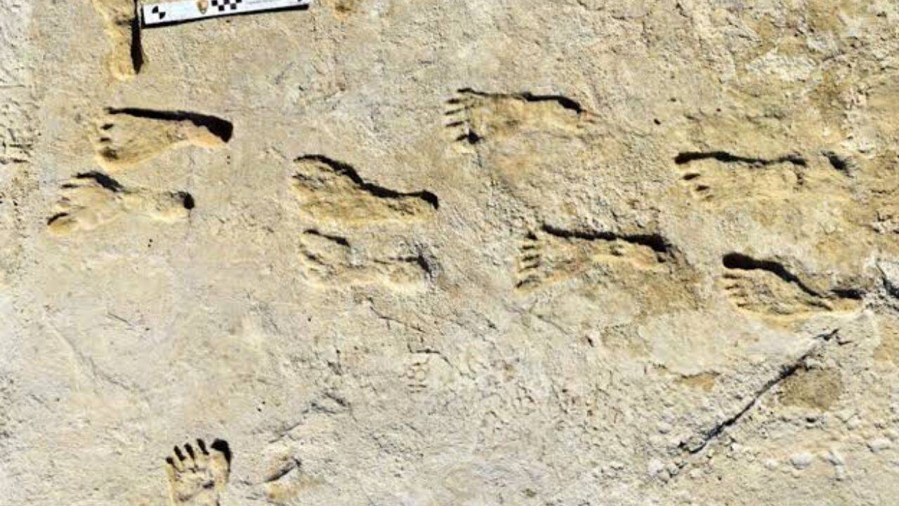
The debate over when humans first arrived in the Americas has bypassed the limits of traditional stone-tool archaeology, shifting instead into the domain of high-resolution geochronology. Empirical evidence uncovered at Lake Otero within the Tularosa Basin of White Sands National Park, New Mexico, places human occupation between 21,000 and 23,000 years ago. This timeline fundamentally disrupts the long-standing Clovis-first paradigm, which caps human entry at approximately 13,000 to 16,000 years before present (BP). To validate a shift of this magnitude requires looking beyond the visual presence of the footprints and conducting a rigorous analysis of the underlying stratigraphic, biological, and radiometric data.
The core challenge to accepting the White Sands data does not stem from the integrity of the tracks themselves, which show clear anatomical definition including distinct heel impressions, medial arches, and toe pads. Rather, the controversy centers on the integrity of the closed-system assumptions inherent in the dating techniques. Evaluating this site requires analyzing three independent chronological systems used to cross-verify the timeline, diagnosing the taphonomic metrics of the trackways, and evaluating the resulting geopolitical bottlenecks for human migration during the Last Glacial Maximum (LGM).
The Triple-Engine Chronological Framework
Evaluating the age of the White Sands trackways requires isolating three distinct physical mechanisms. Initial skepticism focused heavily on anomalous carbon loops, forcing researchers to deploy independent methodologies to isolate and measure different physical properties within the exact same stratigraphic horizons.
                  [ Stratigraphic Layer ]
                             │
       ┌─────────────────────┼─────────────────────┐
       ▼                     ▼                     ▼
[ Ruppia Seeds ]     [ Conifer Pollen ]    [ Quartz Grains ]
 Radiocarbon (14C)    Radiocarbon (14C)         OSL Dating
  (Aquatic Reservoir   (Terrestrial Carbon   (Sedimentary Burial
    Vulnerability)        Verification)         Clock/Sunlight)
1. Radiocarbon Decay of Aquatic Macrofossils
The initial 2021 temporal baseline relied on the beta decay of carbon-14 ($^{14}\text{C}$) extracted from the seeds of the aquatic ditchgrass Ruppia cirrhosa, embedded directly within and between the footprint-bearing sediment layers. The primary data yielded calibrated age clusters of $22,860 \pm 320$ years BP and $21,130 \pm 250$ years BP.
The structural flaw in this metric is the hard-water effect. Because Ruppia cirrhosa is an submerged aquatic plant, it assimilates dissolved inorganic carbon (DIC) from the local hydrologic basin. If the groundwater supply interacts with ancient, carbon-depleted carbonate rocks (such as local Permian limestone), the plant ingests "dead carbon" that has already lost its $^{14}\text{C}$ fraction. This systematic error artificially inflates the apparent radiocarbon age, potentially skewing the dates older by several millennia.
2. Terrestrial Pollen Isolation via Flow Cytometry
To bypass the aquatic reservoir bottleneck, subsequent validation shifted to terrestrial bio-indicators. Conifer pollen grains (Pinus spp.) preserved within the same stratigraphic clay laminae were isolated. Because conifers exchange carbon directly with the atmosphere via respiration, their tissue reflects true atmospheric $^{14}\text{C}$ concentrations at the time of growth, rendering them immune to the hard-water effect.
Isolating a clean sample required breaking down two-pound sediment blocks using aggressive acid matrices to dissolve the surrounding mineral matter down to a single cubic centimeter of concentrate. Researchers then applied flow cytometry, using laser-induced fluorescence to sort and isolate approximately 75,000 individual pollen grains per sample. The resulting AMS (Accelerator Mass Spectrometry) radiocarbon measurements tightly correlated with the original seed dates, yielding statistically indistinguishable ages that confirmed the 21,000 to 23,000-year timeline.
3. Optically Stimulated Luminescence (OSL) of Sedimentary Quartz
The third line of verification completely bypasses organic radiocarbon decay. OSL measures the time elapsed since mineral grains were last exposed to ionizing sunlight. While exposed at the surface, quartz grains are bleached, resetting their internal electron traps to zero. Once buried by subsequent sediment layers, ambient ionizing radiation from the surrounding soil matrix (derived from the decay of uranium, thorium, and potassium) knocks electrons into stable traps within the quartz crystal lattice at a predictable rate.
By exposing sub-surface quartz samples from the footprint horizons to controlled laboratory light, researchers measured the photons released as trapped electrons escaped. This luminescence signal established a minimum burial age of approximately 21,500 years BP. Because OSL measures a completely independent physical phenomenon—ionizing radiation dosage rather than isotopic decay—it serves as a critical check against organic contamination or old-carbon recycling.
Taphonomic Metrics and Demographics
The White Sands site represents an active, wet-playa ecosystem characterized by fluctuating water levels and rapid mineral precipitation. The preservation of thousands of footprints across seven distinct soil horizons implies specific environmental and behavioral patterns.
[ Human / Megafauna Interaction ] ──► Mud Displacement Matrix ──► Gypsum Cementation
The physical trackways reveal a highly specific demographic signature. Analysis of stride lengths and footprint dimensions indicates that the vast majority of the tracks were left by children and adolescents rather than adults. A behavioral model published by Bennett et al. suggests a structured division of labor within LGM hunter-gatherer cohorts. High-risk, high-skill tasks (such as hunting megafauna or long-range foraging) likely engaged the adult population elsewhere, while resource transportation, water fetching, and localized maintenance tasks were delegated to younger group members.
The physical trackways also document precise behavioral interactions with extinct Pleistocene megafauna. In one continuous trackway, an individual’s footprint paths intersect those of a Columbian mammoth (Mammuthus columbi). The footprints demonstrate that the human walked for nearly a mile, occasionally carrying a toddler—indicated by localized weight-bearing mud displacement and secondary infant prints.
The structural sequence of the tracks proves that the mammoth crossed the human path afterward without altering its stride or showing signs of alarm, while human tracks later stepped directly into the fresh mammoth depressions. This physical overlap provides undeniable proof of co-existence within a compressed temporal window, ruling out any possibility that the human and megafaunal remains were mixed together by later geological activity.
The Migration Bottleneck
Solidifying the human presence in New Mexico at 23,000 years BP introduces a profound geographic paradox. This timeline places humans south of the continental ice sheets during the absolute peak of the Last Glacial Maximum, when the Laurentide and Cordilleran ice sheets coalesced to form an impenetrable glacial barrier across modern-day Canada.
       [ BERINGIAN POPULATION COHORT ]
                      │
         ┌────────────┴────────────┐
         ▼                         ▼
  Coastal Route             Ice-Free Corridor
  (Deglaciation Only)       (Closed during LGM Peak)
         │                         │
         ├─────────────────────────┘
         ▼
[ White Sands Presence: 23,000 BP ]
This geographic constraint challenges standard entry models across two specific pathways:
- The Ice-Free Corridor Inconsistency: Standard models suggest that interior migration was dictated by the opening of a low-elevation corridor between the major ice sheets. However, geomorphological data confirms this corridor did not open until approximately 14,000 to 15,000 years BP. A human presence at 23,000 years BP requires entry long before the ice sheets merged, or via an alternative route entirely.
- The Coastal Migration Timeline: If populations bypassed the continental interior by moving down the Pacific margin using watercraft, this transit must have occurred prior to the closing of coastal bottlenecks by marine-terminating glaciers, pushing the initial entry into the Americas back to 25,000 to 30,000 years BP.
This chronological tension exposes a clear split in modern archaeological interpretation. Either early human populations entered the Americas during an earlier interglacial window (such as Marine Isotope Stage 3) and maintained low-density populations for thousands of years, or the current genetic models detailing the separation of Native American ancestors from Siberian populations require a complete overhaul.
The scientific consensus can no longer dismiss the White Sands data as an analytical anomaly. The alignment of atmospheric radiocarbon dating via conifer pollen with sedimentary burial clocks via OSL eliminates the hard-water errors that compromised the initial seed data. Future field research must pivot away from looking for traditional stone tools to confirm these early dates. Instead, efforts must focus on high-density stratigraphic sampling of low-energy lacustrine environments across the Southwest, targeting intact, multi-system chronological sequences to map out the true baseline of human arrival in the Western Hemisphere.